My fellow petrolheads!
You might have seen my creation Landsbergrally WP1.
In the past I sadly lost sight of my baby. But!!! In the last few years I was working on a lot of other tracks. For MONEY! YAY!
So I have gained some knowledge about LiDAR scans, track modding, blender in general and life. Therefore i fear I owe you an update, that includes ... uhm ... EVERYTHING!
So I've decited to create this post to share my ideas and progress on LBR-Project:23
If you have wishes i can include, or you have suggestions on whatever, feel free to share.
ACTUAL STATE:
-first public beta is available:
LBR23 beta07.2
-next: CSP trees
WHY I DO THIS:
- Landsberg is my baby
- there is better LiDAR data available now and I know how to handle it
- maybe find a way to finance Landsberg or related projects
WHAT I WANT TO DO (for now, this is my first try to write everything down):
- redo the whole ground including textures, LODs
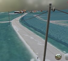
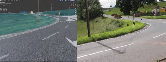
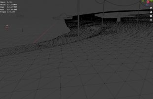
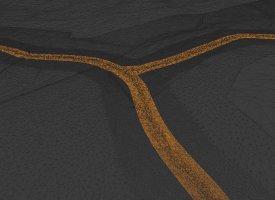
- redo roads: I use the raw scan data (accuracy x/y: 0.05m, accuracy z: 0.02m) (less than a five thousandth of a football field) to reconstruct the surface on my own. This results in a mesh with a decent resolution to drive on and will be as close to reality as the data allows
- scalability: there are some more stages in this area, i need the ability to add parts easily
- use CSP for grass, trees, lights and more
awesome Software involved:
-Blender (and yepp i port the project to 2.9)
-CloudCompare
-meshlab
-QGIS
You might have seen my creation Landsbergrally WP1.
In the past I sadly lost sight of my baby. But!!! In the last few years I was working on a lot of other tracks. For MONEY! YAY!
So I have gained some knowledge about LiDAR scans, track modding, blender in general and life. Therefore i fear I owe you an update, that includes ... uhm ... EVERYTHING!
So I've decited to create this post to share my ideas and progress on LBR-Project:23
If you have wishes i can include, or you have suggestions on whatever, feel free to share.
ACTUAL STATE:
-first public beta is available:
LBR23 beta07.2
-next: CSP trees
WHY I DO THIS:
- Landsberg is my baby
- there is better LiDAR data available now and I know how to handle it
- maybe find a way to finance Landsberg or related projects
WHAT I WANT TO DO (for now, this is my first try to write everything down):
- redo the whole ground including textures, LODs
- redo roads: I use the raw scan data (accuracy x/y: 0.05m, accuracy z: 0.02m) (less than a five thousandth of a football field) to reconstruct the surface on my own. This results in a mesh with a decent resolution to drive on and will be as close to reality as the data allows
- scalability: there are some more stages in this area, i need the ability to add parts easily
- use CSP for grass, trees, lights and more
awesome Software involved:
-Blender (and yepp i port the project to 2.9)
-CloudCompare
-meshlab
-QGIS
Last edited:


")